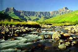
Royal Natal National Park
Royal Natal National Park boasts some of the most splendid mountain scenery
in Africa. The
main feature is the world famous Amphitheatre,
a rock wall approximately five km in length, and 500m high. Above the
amphitheatre is Mont-aux-Sources
peak where, as its name implies, the Orange river starts its long journey
to the Atlantic ocean and Thukela river cascades down the face of the
amphitheatre, in one of the highest waterfalls in the world, on its way
to the Indian ocean.
 The
most popular activity at Royal
Natal National Park is undoubtedly hiking. A comprehensive hiking guide
is available for purchase at the Visitor Centre, at Tendele camp office
and at the main entrance gate. The brochure shows a map of the Royal
Natal National Park and the network of hiking paths which visit every
part of the park from the gentle walk to Fairy Glen to the challenging hike
up the Crack and down the Mudslide. The
most popular activity at Royal
Natal National Park is undoubtedly hiking. A comprehensive hiking guide
is available for purchase at the Visitor Centre, at Tendele camp office
and at the main entrance gate. The brochure shows a map of the Royal
Natal National Park and the network of hiking paths which visit every
part of the park from the gentle walk to Fairy Glen to the challenging hike
up the Crack and down the Mudslide.
Trout fishing at
Royal Natal is available in two dams in the park and in the Mahai and
Thukela rivers, and picnicking and swimming in the clear mountain streams
are popular pastimes.
 The
stables at Rugged
Glen provide opportunities to ride into the mountains for unique views
and sightings of mountain reedbuck and grey rhebuck that seem to have
no fear of people on horse back. The
stables at Rugged
Glen provide opportunities to ride into the mountains for unique views
and sightings of mountain reedbuck and grey rhebuck that seem to have
no fear of people on horse back.
Accommodation in Royal Natal National Park
- Cascades and McKinlay's Pool: Take the campsite road to the casual car
park.
Walk along the road past the campsite. Fifteen minutes' walk brings you to
the Queen's Causeway and the Cascades.
From there a good path leads to McKinlay's Pool at which point the Gudu
stream meets the Mahai. (Round trip 5 km : 1 hour).
To make a round trip, though the going is very steep, a footpath leads up
towards Dooley from the boulders near McKinlay's pool, joining the Tiger
Falls/Gudu Bush path.
Return via Tiger Falls or Gudu Bush. (Whole trip 8 km : 1 hour 45 minutes).
- Fairy Glen: Start down the main road and cross the bridge opposite the
Visitor Centre.
Then take the path to the left leading through the bush to the Broome Hill
stream.
Cross and re-cross this, then follow up through the bush to the waterfall.
This glen is well named and is a delightful picnic spot on a hot day. (1,6
km : 20 minutes).
To make a round trip from Fairy Glen: continue along the bridle path,
turning left back to the hotel at the fIrst crossroads, or left just beyond
these crossroads, along a path which leads to the main campground. (Whole
trip 4 km : 45 minutes).
- Otto's Walk: This walk starts at the far side of the Visitor Centre car
park.
It is a self-guided trail of some three kilometres and takes about 45
minutes to complete.
A booklet providing information on the walk is obtainable from the Visitor
Centre.
Many trees are identified and the walk is signposted all the way.
- Tendele Camp: The hutted camp established at the back of Dooley, high
up on the side of the mountain, commands a wonderful view of the
Amphitheatre with the Policeman's Helmet and Vemvaan Valley in the
foreground.
There is a road to the camp but only residents may take their cars beyond
the signposted Gorge parking area.
This makes a nice morning's walk from the hotel area, travelling along the
motor road. (5 km : 1 hour 30 minutes).
Proceed back to the hotel or camping area along the path which starts on the Thendele road below the Lodge and passes below the camp extension to the
eastern end of the natural forest and on to meet the hotel/Tiger Falls path.
(Whole trip 10 kIn : 2 hours 30 minutes).
- Gudu Falls: From Thendele take the path past Tiger Falls to the Gudu
Bush. Soon after the stream is crossed a path to the left will be seen which
leads to these magnificent falls.
From the hotel, cross the Mahai below the casual car park and proceed up the
hill to the four-way junction, turning left.
Here the path for those starting from the main campground will be met.
Continue on past the turn to the Mudslide and into the forest.
Turn right at the signpost and follow the steep path above and out of sight
of the stream for about I 600 metres, when the Gudu Falls will be reached.
(4 km : 2 hours). (Whole trip 9 km : 3 hours 30 minutes).
- Doolev Waters and the Mahai Valley: Proceed to the upper end of the Gudu
Bush (see Walks Nos 8 and 11).
Continue up the valley on the main bridle path overlooking the Mahai stream
for about 2,5 km.
Cross the Mahai stream, a very attractive picnic spot, and continue up the
north-facing slope until a path junction is reached.
Turn left up the Dooley Waters path, or alternatively right to continue
further up the Mahai valley to Basuto Gate. Campsite via Cascades path junction 7 km : 2 hours, 30 minutes).
NOTE: The Nek and the path from the Nek to the Basuto Gate path are closed.
The Dooley Waters path is therefore a cul-de-sac.
- Mahai Falls and Basuto Gate: At the Dooley Waters/Basuto Gate path
junction (see Walk No 12) turn right to continue further up the Mahai Valley
to the Mahai Falls.
This is a popular picnic spot with an inspiring view down the valley.
From this point the path up to Basuto GateIWitsieshoek Mountain Resort is
obvious.
On reaching Basuto Gate/Witsieshoek Mountain Resort it is a short walk over
the ridge (the boundary of Qwa Qwa) where one gets magnificent views of the
Malutis, often snowclad in the winter months.
The word 'Mahai' is Sesuto for 'rocky krantz'. (11 km : 3 hours 45 minutes).
To make the round trip, from Basuto Gate continue along the path on the near
side of the fence for about three kilometres, crossing the source of the
Gudu Stream on the way.
Then continue to the Crack (Walk No 14) or to the top of Gudu Falls, and
then back via the Mudslide. (Whole trip 24 km : 6 hours 30 minutes).
- The Crack and the Mudlslide: From Gudu Bush (Walks Nos 8 and 11)
continue up the valley for another 1 200 metres where a path will be seen
leading towards the Crack.
The climb is very steep but a short chain ladder helps one over the only
difficult section.
On reaching the top, bear right onto the high ground overlooking the Mahai
valley and make straight for the top of the Gudu Falls, where an easy
crossing of the Gudu stream can be made about 50 metres up.
This is a favourite place for a swim, and a good picnic spot.
Directions are hardly needed for scaling Plowman's Kop, from which point a
magnificent view is obtained.
Return down the Mudslide. This starts beyond the far corner of Plowman's
Kop.
The decent is very steep and loose and, after rain, slippery .The short
chain ladder at the start is helpful.
At the foot of the cleft, follow the main path round to the right until it
joins up with the hotel path and turn left for home. (Whole trip 11 km : 4
hours 40 minutes).
NOTE: The Mudslide is not suitable for young children or those suffering
from fear of heights.
- The Grotto: The route from Thendele is described above.
From Rugged Glen proceed past the Camel, Surprise Ridge (Walks Nos 7 and 15)
and on to the Grotto.
From the hotel/main campground area proceed as for Sunday Falls (Walk No 4),
but soon after passing the four-way junction and just short of the Fairy
Glen Stream, turn left up the Broome Hill valley.
Continue climbing steadily until the Grotto forest is reached.
Eventually, the path comes to a dead end, but some ten metres before this a
faint path can be seen leading upwards to the left, and a ten minute walk
brings you to the Grotto.
The Grotto is in two parts, consisting of two huge gorges cut through the
sandstone, and both are worthy of exploration. (5 km : 2 hours). (Whole trip
10 km : 3 hours 30 minutes).
- The
Gorge Walk: From Thendele, proceed down to the Tugela
river, where the main Gorge path will be reached. From here the route
is obvious. From the hotel/campground area it is possible to save a
three-kilometre walk by driving to the foot of the Thendele hill, where
parking will be found and the Gorge path proper starts. If walking,
a more interesting route, enabling one to avoid the road, is to go via
Thendele camp. There is no more popular nor picturesque walk than the
Gorge walk; it should not be missed, and to enable you to make the most
of the trip, take a full day over it. For the first 6,5 kilometres beyond
the foot of Thendele hill there is a very good path and no steep climb.
No special directions are really needed. The path winds along, above
and parallel with the Tugela river . Not long after crossing the intersection
stream from Devil's Hoek, look out for the Policeman's Helmet on the
high ground to the right overlooking Vemvaan Valley. The last 1 600
metres through the Gorge entails three crossings of the river (simple
enough unless in flood). Many visitors to the Gorge turn back at the
first crossing. This is a pity, as the most picturesque scenery at Royal
Natal lies at the far end, and walking the additional 600 metres is
rewarding. Cross the stream and re-cross, keeping to the path which
is on the right-hand side of the Gorge, and keep on until you reach
the chain ladder on the cliff on the right-hand side. The chain ladder
is at the mouth of the tunnel. This tunnel is approximately 55 -65 metres
long. Use the chain ladder to skirt the tunnel or scramble through the
tunnel, though a ducking is likely, and so get into the Amphitheatre.
Boulder-hop up the Tugela for about 800 metres, where each few metres
gives you a complete change of scenery. A steep path up the left-hand
bank of the Eastern Buttress Gully leads to the Tunnel Cave. If you
stand with your back to the chain ladder, this path will be directly
in front of you. From the cave there is a wonderful view of the Amphitheatre
wall, with the Sentinel on your right, and you will be able to look
over the Tunnel. If you proceed around the cave you will obtain an excellent
view down the valley towards the hotel. Warning: keep a lookout for
thunderstorms, as a heavy storm may bring down the river and delay your
return trip by a few hours. The best spot to picnic is at the end of
the path, (11 km : 3 hours). (Whole trip 22,5 km : 5 hours 30 minutes).
- Devil's Hoek Valley: Start as for the Gorge Walk.
Shortly after leaving the forest (10 minutes) a signpost points the way up
the valley.
Some ten minutes' walk from here, on the right, you will notice a large rock
on which there are some Bushman paintings.
Continue through a large patch of forest, uphill across an open section and
into a second area of forest.
At this point the path ends, and any further progress is hard going. (Whole
trip from the Gorge car park 6 km : 2 hours).
From Thendele camp Devil's Hoek Valley is within a thirty-minute walk.
|


